Museum “Throws Shade” on Urban Heat Islands
The intersection of climate education, action, and urban planning
As I mentioned in my last post, if your museum focuses any of your educational offerings on climate change, crossing paths with municipal planning is inevitable – and that’s a really good thing. Case in point: the Science Museum of Virginia’s (SMV) community science heat mapping project, “Throwing Shade in the RVA”.
With funds from the National Oceanic and Atmospheric Administration (NOAA) Environmental Literacy Program (ELP), the museum set out to increase climate literacy, with the ultimate goal of sparking climate action and resilience. In Richmond, where SMV is located, urban heat islands are the most notable local impact of climate change. However, existing temperature data--measured at airports by satellite--wasn’t personally meaningful to most people. Looking for a way to gather more relatable measures of heat islands, the museum’s (former) Chief Scientist Jeremy Hoffman built a project around the work of Vivek Shandas, a professor of Urban Studies and Planning at Portland State University. Using Shandas’ methodology, Hoffman and his colleagues enlisted youth from Ground Work RVA in a community-based participatory research project (formerly called “citizen science”) to take “the city’s temperature”, gathering neighborhood-by-neighborhood heat data. The project participants documented a 16-degree Fahrenheit difference in afternoon temperature between Richmond’s coolest and hottest neighborhoods.
When the museum publicized the results as a heat vulnerability map, planning issues past and present jumped into focus. The hottest neighborhoods are predominantly Black and Brown neighborhoods where heat-mitigating green space and trees are scarce – by design, thanks to 20th Century city planner Harland Bartholomew, who explicitly based his designs of Richmond (and hundreds of U.S. cities) on Federal redline maps. As the museum’s data maps went public, Richmond’s city planners took notice, and incorporated the heat vulnerability data and map into the City’s first climate action plan, RVAgreen 2050. Hoffman has since served as a member of the Environment Working Group for Richmond’s full city master plan, Richmond 300.1
Here are just a few reasons why this project is a perfect lesson for Planning-Curious Museum People:
It’s Rooted in the Real.
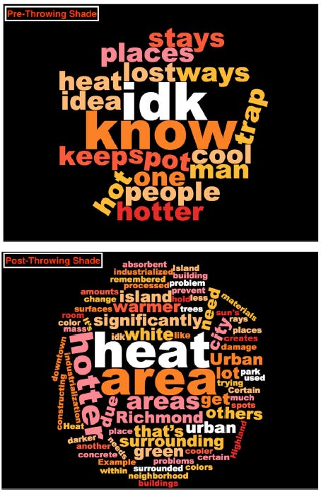
We museums strive to give people direct experience with the real - real art, real objects, real nature. For climate science education, nothing gets more real than the local, observable impacts of climate change. Take a look at the impact Throwing Shade participants’ understanding of urban heat islands before and after participating in the data collection.

It Ties Things Together.
Heat island effect is the perfect example of how tightly intertwined all urban planning issues are: urban design (past and present), targeted disinvestment and institutional racism, health inequalities, and climate and environmental justice. Looking at the museum’s heat vulnerability data maps, the Richmond Ambulance Authority quickly noticed that the data coincided strikingly with ambulance call frequency data.
It Should Inspire History and Art Museums, too.
The project shows that there’s plenty of potential content for non-science museums in heat islands and climate change: redlining is the perfect illustration not just of institutional racism, but of the way history has quite literally shaped the design of our cities today. This heat mapping has been repeated in 60 additional cities (and counting)2, with the same redline-driven results. Definitely check if your city or county is one of them. If not, it still might be one of the 500 cities, counties, regions, or states designed by Harland Bartholomew. And, art museums, here’s a guide, Cool It With Art, (produced by a planning agency!) for using public art as a tactic for dealing with rising temperatures.
It Involved Grassroots Partners.
The museum partnered with a local grassroots organization that works on urban planning-related issues - Groundwork RVA – before it ever crossed paths with city officialdom. While I encourage museums to forge relationships with government planning agencies, municipal planners’ ability to partner with you will vary from town to town, city to city, and from election cycle to election cycle. (Witness US Federal environmental agency employees’ waxing and waning freedom to discuss climate change under different presidents.) But - local grassroots organizations are doing The Work, year-in, year-out: planting urban food forests, repurposing vacant lots for art installations, or outdoor urban climbing space.
Whether you work with “official” planners or not, you need to be supporting the hands-on grassroots folks – they work where the rubber meets the road (or, better, where the roots meet the soil)
~ Betsy Loring3
The Planning-Curious Museum Person
Sharing stories and ideas for other Planning-Curious Museum People and for Museum-Curious Planning People.
As the partnership between the museum and Groundwork RVA extended to a project gathering and mapping neighborhood air quality, impacting City planning only grew in importance. The summative evaluation report by KERA Collective includes this gem about project goals: “[O]ne Groundwork RVA staff member recalled how their collaboration began with the goal of finding evidence for environmental issues in redlined neighborhoods. After collecting and analyzing data, their goals shifted toward implementing change in Richmond’s master planning (such as advocating for climate solutions and more parks and green spaces).” (Emphasis added.)
The expanded heat mapping work is being carried out through NOAA’s Heat Mapping Campaign and CAPA Strategies’ Heat Watch.
When she’s not wearing her planning-curious hat, Betsy Loring is the Principal of expLoring exhibits & engagement, where she offers 20 years’ experience in project management and exhibit development in multidisciplinary, indoor and outdoor museum settings. Her services include exhibit master planning, content and interactive development, and writing, with a focus on hands-on STEM. She also offers staff training in exhibition planning, formative evaluation, and prototyping. Special interest in multi-institutional collaborations, staff capacity-building, and of course – collaboration with municipal planning practitioners.


